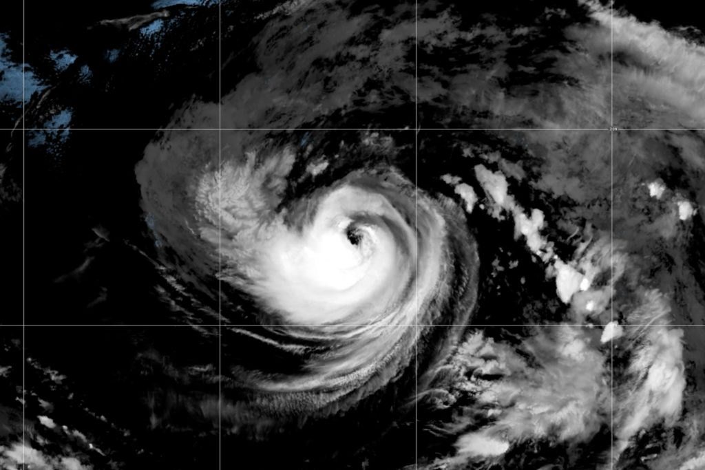
Hurricane Karina has strengthened in the open Pacific Ocean, far from any coastline, and forecasters expect it to intensify into a major storm in the coming days. The system, which formed from a tropical storm, is not projected to make landfall, but its effects are expected to be felt along the shores of southwest Mexico and the Baja California Peninsula.
The U.S. National Hurricane Center reported that Karina reached hurricane status while positioned well away from land. Forecasters said the storm is likely to continue strengthening and could reach major hurricane intensity, a classification given to storms with sustained winds of at least 111 miles per hour. The exact track remains uncertain, but all current models keep the system over open water.
Although Karina is not expected to threaten land directly, the hurricane center warned that swells generated by the storm are likely to cause dangerous surf and rip current conditions along parts of the Mexican coastline. Beachgoers and mariners in those areas were advised to monitor conditions and heed local warnings, as rip currents can be deadly even when a storm remains far offshore.
The storm's development comes during an active period in the eastern Pacific hurricane season, which typically runs from mid-May through November. The region has seen several named storms this year, and forecasters have noted that warm ocean waters and favorable atmospheric conditions are contributing to above-average activity. Karina is the latest system to emerge in a season that has already produced multiple hurricanes.
Meteorologists are also watching the broader weather pattern across the Pacific, as conditions that favor tropical cyclone formation remain in place. While Karina poses no direct threat to populated areas, its rapid intensification serves as a reminder of the power of these systems and the importance of early warning systems for coastal communities.
Residents along the southwest coast of Mexico and the Baja California Peninsula should expect elevated surf through the coming days, even as the storm moves farther away. The hurricane center said the swells could produce life-threatening surf and rip currents, particularly on south-facing beaches. Local officials have not announced evacuations, as the storm is not expected to approach land.
Forecasters will continue to track Karina as it moves westward across the Pacific, providing updates on its intensity and path. The system is expected to remain a hurricane for several days before gradually weakening over cooler waters. No coastal watches or warnings are currently in effect, and the primary concern remains the hazardous marine conditions generated by the storm's swells.
147