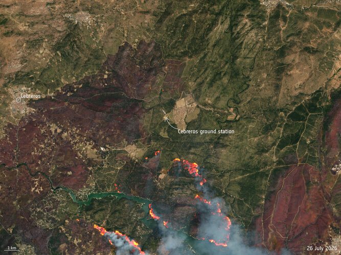
Wildfires burning near Madrid have encroached on the area surrounding the European Space Agency's Cebreros ground station, a critical facility for deep-space communications. A satellite image captured on July 26 by the Copernicus Sentinel-2 mission shows the scale of the blazes close to the installation, which lies in the municipality of Cebreros in the province of Ávila, about 100 kilometers west of the Spanish capital. The fires, which have been described as raging by local authorities, pose a direct risk to the station's operations and highlight the increasing vulnerability of essential infrastructure to extreme fire seasons fueled by climate change.
The Cebreros ground station is one of ESA's three deep-space antennas, used to communicate with missions exploring the solar system, including spacecraft en route to Mars, asteroids, and comets. The station's 35-meter dish antenna plays a vital role in receiving telemetry and sending commands to agency probes. Any disruption to its operations could jeopardize data return from ongoing missions, underscoring the importance of protecting such facilities during natural disasters. While the exact proximity of the flames to the station has not been detailed, the imagery indicates that the fires are burning in the surrounding forests and hillsides.
The Copernicus Sentinel-2 mission, part of the European Union's Earth observation program, provided the high-resolution image that captured the wildfire's advance. The twin satellites of the Sentinel-2 constellation regularly monitor land surfaces, offering critical data for disaster management, including fire detection, burn scar mapping, and damage assessment. The image used to assess the threat near Cebreros was processed by ESA and released to draw attention to the ongoing emergency. Such real-time satellite surveillance allows emergency services to plan containment strategies and evaluate the impact on populated areas and infrastructure.
Spain has experienced an intense wildfire season during the summer of 2026, with numerous outbreaks recorded across central and southern regions. Prolonged drought conditions and heatwaves have created a tinderbox landscape, making it difficult for firefighters to control blazes once they ignite. The fires near Madrid are among the most concerning due to their proximity to both urban centers and strategic installations like the Cebreros station. Local firefighting crews, supported by aerial units, have been working to create firebreaks and protect the facility, but shifting winds and dry vegetation continue to hamper their efforts.
The incident underscores a broader trend of wildfires increasingly threatening critical infrastructure worldwide. Satellite monitoring has become an indispensable tool for early warning and response, providing data that helps authorities prioritize resources and evacuate vulnerable areas. The Cebreros station itself is built to withstand some environmental stresses, but the intensity of modern wildfires, exacerbated by climate change, tests the limits of standard protective measures. ESA officials have not publicly commented on any damage to the station, but the imagery serves as a stark reminder of the risks faced by space assets on the ground.
In the wake of the fires, discussions about reinforcing fire defenses around key scientific sites are likely to intensify. The use of satellite imagery from missions like Sentinel-2 not only helps in immediate crisis management but also aids in long-term planning for fire prevention and land management. As the wildfire season progresses, the situation near Cebreros will be closely watched by space agencies and emergency managers alike. The combination of state-of-the-art earth observation and on-the-ground firefighting will be crucial in ensuring that vital infrastructure remains operational.