Romania recorded two earthquakes less than a day apart over September 6 and 7, but the official data show that they were very different events beneath the surface.
The latest earthquake occurred at 1:08:59 a.m. local time on September 7 in the Moldova–Galați region. Romania’s National Institute for Earth Physics, INCDFP, assigned it a local magnitude of ML 3.1 and a depth of 16.8 kilometers. The institute classifies the event as a shallow, local earthquake and lists its intensity as I.
Its epicenter was about 32 kilometers south of Galați, 40 kilometers south of Brăila and 40 kilometers southeast of Focșani. Izmail, across the border in Ukraine, was about 94 kilometers north of the epicentral area, while Tulcea was about 98 kilometers away.
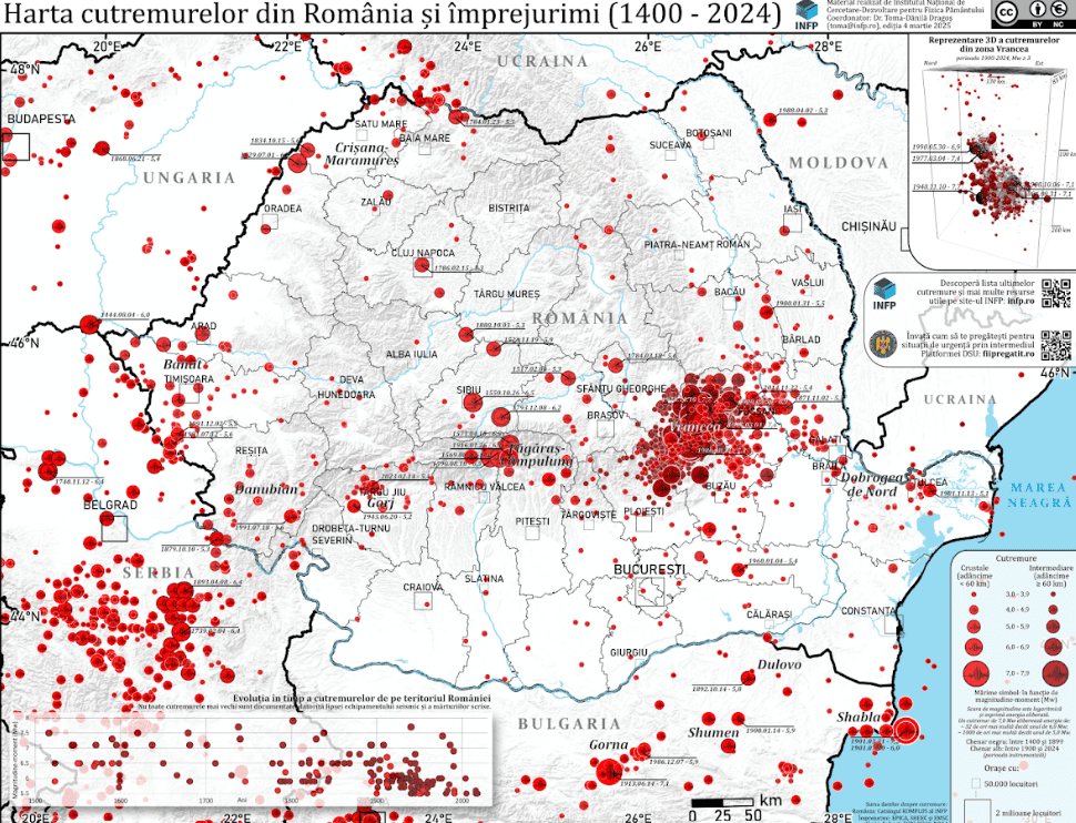
The reviewed manual solution places the September 7 source at 45.5498°N, 27.6615°E. Those coordinates matter because they put the event in a shallow crustal setting near the lower Danube rather than in the deep Vrancea source region that dominates many discussions of Romanian seismic risk.
The previous morning, September 6, INCDFP recorded a stronger earthquake in the Vrancea seismic zone in Buzău County. That event had a local magnitude of ML 4.1, but its source was much deeper: 149.6 kilometers below the surface. The institute classified it as an intermediate-depth earthquake and assigned intensity II.
Those depths matter because Romania experiences more than one kind of tectonic earthquake. INCDFP explains that Romanian tectonic earthquakes can occur on crustal faults at depths of less than about 60 kilometers, or at intermediate depths of roughly 60 to 200 kilometers. The Galați earthquake sits firmly in the shallow crustal category. The Vrancea event, at nearly 150 kilometers, is a textbook example of the intermediate-depth class used by the institute.
The contrast is larger than the raw numbers first suggest. The Galați source was nearly nine times shallower than the Vrancea source. That does not make it more dangerous; it simply means the seismic waves began their path to the surface under a very different geometry. Depth, source distance and local geology all affect how shaking is distributed.
Magnitude tells a different part of the story. It is a measure related to the energy released at the source rather than a direct measure of what people at a particular location will feel. INCDFP notes that the magnitude scale is exponential: an increase of one magnitude unit corresponds to roughly 30 times more released energy. On that approximation, an ML 4.1 event represents far more energy release than an ML 3.1 event.
But greater source energy does not translate into a simple, fixed pattern of shaking at the surface. INCDFP’s educational material emphasizes that ground-motion amplitude depends on several factors, including magnitude, epicentral distance, hypocentral distance, topography and local geological conditions. Depth changes the geometry of how seismic waves reach populated areas, while local soil and rock can alter how those waves are experienced.
This is also why magnitude and intensity should not be used as interchangeable labels. The September 7 event had a measured local magnitude of 3.1, while the institute assigned intensity I to its observed or expected effects. The September 6 event was ML 4.1 with intensity II. One number describes the event at its source; the other describes the strength of effects in a place.
That distinction is particularly useful in Romania because Vrancea is known for earthquakes originating at intermediate depths, while other regions can produce shallower crustal events. The two September earthquakes therefore should not be treated as interchangeable examples simply because they occurred close together in time.
The official records also do not present the pair as a single linked sequence. They are listed in different regions, with different depths and different classifications. Temporal proximity by itself does not establish that one event caused the other.
For the September 7 earthquake, Romanian media reported no casualties or material damage by the morning after the event. That absence of reported damage is consistent with the institute’s low intensity assignment, but it is not a substitute for the seismic measurements themselves.
The pair is useful precisely because it shows how much information is lost when an earthquake is reduced to one headline number. Magnitude describes source size, depth places the rupture in the crust or deeper lithosphere, location defines which communities are closest, and intensity describes effects at the surface.
Romania’s seismic network continues to monitor both crustal and intermediate-depth activity. For public interpretation, the most useful comparison is not simply which magnitude is larger, but how source depth and local geology shape the motion that ultimately reaches the surface.
140